
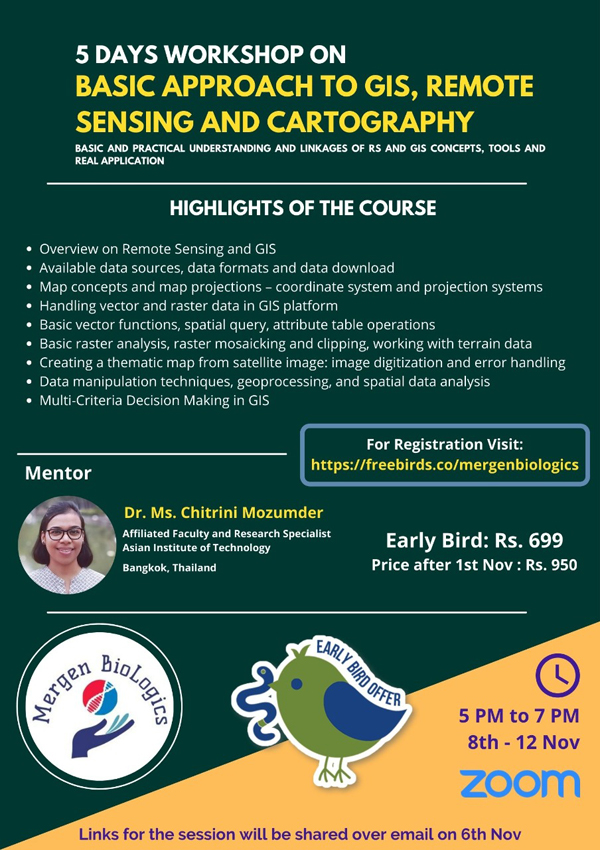
About the course
“People looking to make career in Remote Sensing industry
can foresee big growth across Agriculture, Insurance, Disaster Management,
Energy and many other sectors; but at the same time, you need to be more
technical and solution driven”.
The 5 days course is designed for individuals with
no prior knowledge and will offer essential and practical understanding and
linkages of Remote sensing and GIS concepts, tools and real applications.
Highlights of the Course
1.
Overview
on Remote Sensing and GIS.
2.
Available
data sources, data formats and data download.
3.
Map
concepts and map projections – coordinate system and projection systems
4.
Handling
vector and raster data in the GIS platform
5.
Basic
vector functions, spatial query, attribute table operations
6.
Basic
raster analysis, raster mosaicking and clipping, working with terrain data
7.
Creating
a thematic map from satellite image: image digitisation and error handling
8.
Data
manipulation techniques, geoprocessing, and spatial data analysis
9.
Multi-Criteria
Decision Making in GIS
Pedagogy: Lecture
and Hands-on Exercise
The things you will learn
Conceptual foundations and technical skills to apply
remote sensing and GIS to solve real world problems.
Mentors
Dr. Ms. Chitrini Mozumder
What’s included in the experience
E-certificate and video recording will be provided to the
participants
Schedule
8th – 12thNovember 2021; 5–7 pm
Register
https://www.freebirds.co/experience/096abe0740eb/
Contact
mergenbiologics@gmail.com,
https://www.mergenbiologics.com/;+91-9871650266

![DBT Recruits Scientists [Direct Recruitment with Test and Interview] | 10 Posts]](https://blogger.googleusercontent.com/img/b/R29vZ2xl/AVvXsEgUy3SQQpBYnFIDZ5Y3LElFuqHonNJlPt5y071X98s3wX8-GdTmjzyOnxIqCqSS_fZyggnnCstqk8OGwxdDRoJcUGEr9eR2q_-FicP3EqNvtDQLVPWprvHwAbgxgtnnuOFknLp3ixemzb8u-PAFc1pSYai5DFsY1KpD2caZHFDcT4NUYDlKWI2HUr7vR0Nm/w680/HCD9eT2aoAAd2QQ.jfif)


0 Comments